
Audit-Ready Supply Chain Data
We combine physical farmer registration with precise geospatial mapping to secure global market access for cashew and cocoa exporters.
Four Specialized Field Services
Rigorous data collection systems built for physical agricultural operations and strict international compliance standards.
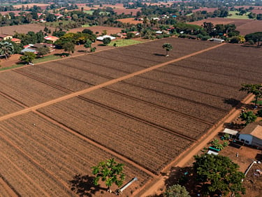
Farm Boundary Mapping
Farmer ID Registration
EUDR Compliance Support
Market Price Monitoring
Boots-on-the-ground GPS polygon mapping of smallholder farms to verify exact production origins.
Structured demographic and household data collection to build clean, traceable first-mile supplier records.
Deforestation risk analysis and geolocation data formatted specifically for European Union import audits.
Real-time commodity price tracking and localized market intelligence across key regional buying centers.
Rigorous Data Verification
Boundary Capture
Data Cleaning
Audit Export
Field teams walk farm perimeters with high-precision GPS units to record accurate polygon coordinates.
Our Lagos-based analysts verify smallholder records against satellite imagery to eliminate overlap errors.
Exporters receive structured, secure datasets ready for direct submission to international buyers.
Secure Your Market Access
Partner with our field teams to map your supply chain and ensure compliance before shipment.